×
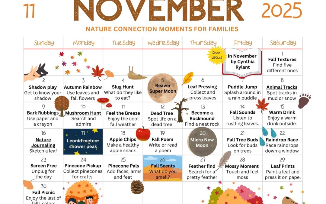
November 2025 Nature Connection Calendar for Families
Hello, November! November holds a special place in my heart. It used to be one of my least favorite months, the beauty of early fall fading, the...


Update April 2019: This post is currently being edited and reworked. If you have questions about pictographs in the South Okanagan please email me directly. Thank you!
Hello, November! November holds a special place in my heart. It used to be one of my least favorite months, the beauty of early fall fading, the...
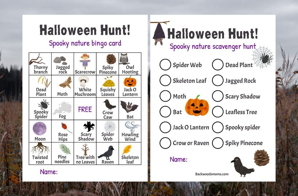
Halloween is here, along with all the spooky, magical things happening in nature as fall deepens. Spiders creep into cozy corners, webs glisten...

Maple Seed Dragonfly Nature Craft From spring well into fall, maple trees are bejeweled with curious winged seeds. Botanically, they’re called...
Scary signage 🙂 I expect that the individual who erected that sign didn’t have a dictionary handy at the time: Persecute vs. Prosecute:
To persecute someone – is to treat them unfairly or in an oppressive way over a period of time because of their race, religion or political beliefs.
“Jews were persecuted in Nazi Germany during the 1930s.”
To prosecute someone – is to press criminal charges against someone in a court of law.
“Illegal file sharers will be prosecuted under new Government plans.”
Hahaha! I actually didn’t notice that. Good eye! Yes, you’re right it’s a pretty harsh sign considering they’re going to persecute trespassers. Yikes!
Hi!
I work for Penticton Indian Band Natural Resources. I’m trying to map all known pictograph locations for preservation, we would love to know the location of the sites mentioned
Hi Kaeloni, I grew up in Penticton and I’m sure you know that John K has found many of them to date. He is a great resource. There is also another one which I found for the band recently JK has the coordinates. Any more I find i will leave a Pin drop with him. Has anyone tried to decipher the images or possible meanings. JK told me stories of the vision quests of the peoples that left them but i am curious of what they could mean. Good luck on your mapping and protection of the areas. I believe its important ,but also believe they should be shared secrets to the ones that truly love or home.
DG
Tried for at least an hour to fund the cave but never did. Your directions to the first site are spot on but after that they lack perspective. There are a lot of trees over trails. If you are facing the first set do you go right and down the hill? I tried going around the entire hill (where the first one is) but nothing. I continued west and went down the hill (went completely around the next hill and up to the top) then I continued down the hill eventually finding another tree over the small trail. Continued along this to a fork. went left but the trail disappeared after about 100 feet. Tried following along this rock face and even climbed up the hill to the top. down and around again. I finally gave up after 1 hour of looking. I continued back to the fork and could see the over grown road (where I had come up) so I ambled down the hill and headed home. Any ideas or better description? Approximately how far past the first set? Thanks for your help.
I’m sorry you couldn’t find the cave. You’re right there are a lot of trails up there and it can be easy to get turned around. I will get up there again and update my directions to make them more clear. You want to continue on the trail that goes straight north, towards Penticton. If you pull up Google Maps (earth view) you can actually see the trail going north, as well as the fork (where you want to stay left). I’ve sent you an email with a highlighted map. I hope this helps. Please let me know if you still have difficulties. Thanks!
I have lived here for 39 years and have never seen pictographs. On my latest attempt I was stopped by a bear. Could you please send me directions for the site above. Also you have a great site. My daughter and her family are moving to the Okanagan and I will share your site with her.
Hi there, Any chance you could share your map with me?
My partner and I tried to find the pictographs today with no luck!
Thanks!
Hi Josee,
Love your pictograph pictures. With Covid here I’ve been social distancing by exploring many of the south Okanagan pictograph sites. Through all my travels though I have not seen the picture listed (https://backwoodsmama.com/2016/02/pictographs-in-south-okanagan.html). Would you be able to share the location of that site with me? It lists this page as being reworked as of April 2019 and to contact you directly for more info. Thanks so much for the help keeping me outside!
Kind Regards,
NIck
Hi there . I live in Kaleden and am a mountain guide who has lived in the community for some 30 years . I am looking for specific information and or location of any know pictographs located between Skaha bluffs PP and Heritage hill to help inform and guide future decisions and policy direction of the access arm of the newly formed Skaha Climbers Association . Specifically in order to help us stay away from them and help preserve them from any impacts of future climbing development in the area we might otherwise inadvertently or unknowingly encourage through our efforts to advocate access with local landowners or the province . Thank you …Peter Arbic. Peterarbic@hotmail.com or 250 497 8958